Island Habitats

Note: The following information about Sapelo Island is adapted from “A Sapelo Island Handbook,” published in 1990 and now out of print. The letters (e.g., Q, P, etc.) are points on the map of Sapelo Island excerpted from the Handbook. If you are interested in a PDF of the original document, please contact Io Hennessy.
Estuaries and Marshes
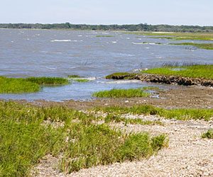
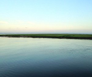 Doboy Sound
All Georgia estuaries are the sites of tremendous water exchange, as there are two tidal cycles daily with an average difference between low and high tides of about 7 feet. During each tidal cycle about 600 square miles of saltmarsh and tidal creeks are drained and refilled. This often means that most of the water returning in the next tidal cycle is the same water, which has recently drained off the marshes. Mixing depends on a number of factors and varies from estuary to estuary.
Doboy Sound is considered an estuary, not in the more classical category of a river mouth entering the sea, but because it drains a substantial area of saltmarsh through a break in the barrier island chain. Also, the salinity is always less than that of oceanic water. This lower salinity is caused by a combination of local runoff, and freshwater input from the major rivers to the north. The Altamaha River to the south sometimes has a major effect when heavy outflow backs up through the network of tidal creeks and the Intracoastal Waterway. This input may then be seen as a front of different colored water running NW-SE along Doboy Sound. Tidal fronts are usually marked by a narrow line of foam and run crossways to the water flow.
The combination of wind strength and direction and tidal flow can produce local boating problems in Doboy Sound. At times the current flow may be substantial, and when there is an ebb tide with an opposing southeast wind, steep waves can make small boat travel uncomfortably rough. This is the summer wind pattern. Conversely a northwest wind opposing and incoming tide may also be rough. Northerlies and Nor-easterlies are not usually a problem. Spring and early summer bring their share of thunderstorms, with the concomitant hazards of lightning, heavy rain and local violent wind squalls, which may also pose problems for small boats.
While the bottom of Doboy Sound is largely composed of clays and silts, sand is present in the outer sound as laminated beds. Near the mouth of the sound, the influence of the adjacent shore is evident in an increased grain size and higher energy bottom structure. High-energy areas may contain deposits of shells. Brittle stars burrow at the sound margins, and the bottom muds are known to contain polychaete worms and the clam Mulinia lateralis. Spring and summer trawls for student groups have produced a wide variety of animals, including crabs; white, brown and mantis shrimps; squid; jellyfish; catfish; star drum, tongue sole and southern flounder. When trawls have been conducted in the winter the numbers and variety of these larger animals are less.
Many microscopic animals may be found in the water itself, larval forms of crabs, fish, polychaete worms, molluscs; copepods in large numbers and of many varieties; ciliated and flagellated protozoans and amebae. Microscopic algae are also present, especially microflagellates, which are extremely important in the productivity of the water column. The seasonal variations in numbers and types of organisms found is considerable, as are the differences between these organisms normally found in the creeks and those of the sound or the open sea.
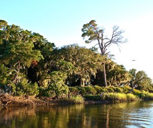 Duplin River
The Duplin River is not a true river. It is a large tidal creek about 11 km in length separating Sapelo Island from Little Sapelo Island and entering Doboy Sound a little south of Marsh Landing.
The water in the creeks is driven by tidal influence. Water is pushed out onto the marsh by the pressure of high tide, and drains from the marsh into the creeks on low tide. This does not mean that the water that returns the next tidal cycle is “new.” On the contrary, the water of the Duplin oscillates backward and forward. The effective exchange of nutrients and organisms is dependent on such factors as water volume and velocity (influencing mixing with the sound and nearshore waters), local fresh water runoff, and the active entry and departure of motile feeding organisms.
At ebb tide the current velocity is greater than during the flood tide, for reasons relating to the hydrology of the Duplin basin. Ebb currents have been measured at 3 ft./second. The amount of water flowing into the river and onto the marshes depends on the height of the tide, substantially increasing on spring tides. Current flows are responsible for the deposition of several bar shoals, where the river makes closely spaced bends in opposite directions.
Despite the murky appearance of its water, the sediments of the bed of the Duplin are low in mud content and contain large accumulations of shell material, much of which is derived from the oyster banks along the riverbanks. At Pumpkin Hammock and Little Sapelo Island the river is eroding Pleistocene sandy deposits. Geological studies have shown the Duplin to be sediment source area (that is, an area losing sediments), rather than an area of sediment accumulation.
The river has been the site of much research since the founding of the Marine Institute. Its nutrient flows and the microflora and fauna have all been intensively studied. Part of the attraction of the Duplin as a site is its accessibility, its oscillating water flow patterns (up and downstream, on and off the marsh), and the fact that its use as a research site for so many years has provided a very extensive data base.
Within the water column itself is to be found a range of organisms. Despite the poor light penetration, microflagellates and other microalgae are remarkable productive. Tintinnids, other ciliates, various amebae and rotifers, predatory and omnivorous copepods, and the larval forms of polychaete worms, gastropods, tunicates and fish are all to be found, varying in numbers and composition with the season. These organisms provide a food source for such fish as juvenile menhaden, a plankton feeder. Menhaden, in turn, are preyed upon by larger fish and birds. Such interaction are all part of the natural checks and balances within any healthy system. Not all of the fish normally found in the Duplin will feed on the same food source or in the same area. For example: flounder are predators who lie on the bottom awaiting an unsuspecting prey; bluefish and yellowtail are also predatory and chase their prey; mullet are deposit feeders; and mummichog (Fundulus sp.) live in the shallower creeks and headwaters where they are rarely threatened by the larger fish. Shrimp utilize the tidal creeks throughout the year, but are especially obvious in summer. Channel Bass will feed on the saltmarsh, but only on the higher spring tides, needing a certain critical depth of water before they will leave the comparative safety of the tidal creek.
Then come the larger predators — dolphin are often seen at Marsh Landing Dock, but if one is especially lucky, they may be seen fishing close inshore in the tidal creeks, actually running mullet into the shallows. Mink hunt by the marsh edge and may sometimes be seen swimming well out in the river.
The birds fall into two groups along the course of the Duplin. Towards the Sound is pelican, gull and tern territory, while further up the river herons and osprey are to be found. Herons come in a variety of sizes, Great Blues with their long legs and necks fish deeper waters than the smaller Snowy Egrets etc., so there is a partitioning of territory between them to their mutual benefit.
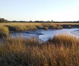 Tidal Creeks
Eugene Odum* [*in Estuarine Perspectives (1980) Academic Press] likens the tidal creeks to a circulatory system, driven by the “heart” of the tide. The analogy is excellent. Tidal creeks do provide fresh input to the saltmarsh each high tide and remove many of the by-products of growth and decay with the ebbing tide. Tidal creeks vary in growth and decay with the ebbing tide. Tidal creeks vary in size down to mere trickles, and form a dendritic pattern over most of the saltmarsh surface.
The creek banks are higher than the saltmarsh lying immediately beyond them, and these natural levees channel the water of the rising tide to the heads of the distributaries and then back in behind the levees in a sheetlike, slowly rising flood. Then, when the tops of the levees are broached, the flow occurs along the entire length of the creek.
This water flow pattern creates sediment deposition behind the levees, which in turn apparently builds up lateral pressure and outward creep which will ultimately cause slumping of the bank into the creek.
A feature of many tidal creeks is the presence of oyster bars. Oysters will settle on solid surfaces when conditions are favorable, the culmination of such growth being an oyster reef. These reefs modify the water flow in tidal creeks, producing pool and riffle structures. Oysters are responsible for much of the modification of runoff from the marsh largely by their action as filter feeders.
A low tide feature of the Sapelo creek banks is their rich golden color. The responsible agents are diatoms, microscopic unicellular algae that grow in a thin film on and in the mud surface, using the energy of sunlight to convert carbon dioxide from the air or the water into organic carbon compounds. Some of these compounds are simple sugars which attract fiddler crabs to the diatom film, and they may be seen foraging over the surface, leaving dull grey-brown mud in their wake.
One of the factors limiting the time available for feeding in the intertidal zone is the temperature tolerance of the organisms. To live on the mud surface requires a great deal of heat tolerance because of the range of temperatures encountered between low and high tides, sunny and dull conditions, and summer and winter extremes.
Having different needs and different areas of interest allows a wide variety of consumers to make optimal use of the same environment. Birds feed at low tide; herons and marsh hens feed in the shallows or on the banks and red-winged blackbirds feed on the Spartina stems looking for seeds and insects. As the tide rises mud snails become active and forage, while the marsh periwinkle and many of the insects which are to be found grazing on the Spartina retreat up the stems. Plankton and juveniles of many species enter with the incoming water and shrimp and some larger fish enter when the water depth is adequate.
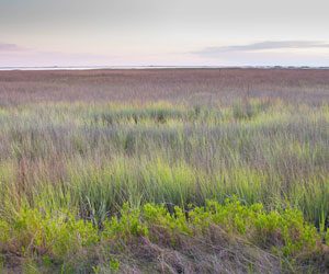 Salt Marshes
At first glance, the Sapelo saltmarsh appears to be composed only of smooth cordgrass (Spartina alterniflora). There are numerous other plants present also, but Spartina is dominant in most of the lower lying, tide dominated areas. Closer inspection will show that the Spartina in the vicinity of the creeks and levees is much taller and more luxuriant than that on the marginally higher ground, where growth is shorter and more sparse.
A number of factors may be influential in determining the height and luxuriance of Spartina. The pattern of water flow through the creek bank is active and the mud is “flushed” by tidal action even though it remains largely anaerobic (all oxygen is used up). On the other hand, the water trapped in the mud of the high marsh behind the levees is not flushed out on neap tides and becomes more saline and stagnant with time. Nutrients are used up, and toxic substances such as sulphide build up. Differences between the creek banks and the high marsh are evident not only in the above ground growth, but also in the root growth and the bacterial interactions occurring within the soil itself. All marsh soils are anaerobic except for the surface few millimeters and around the roots and burrows. The soil bacteria responsible for the breakdown of accumulated organic matter require just such an anaerobic environment. However the rate at which such breakdown occurs and hence the rate at which plant nutrients are made available for new growth appears to be related to the water flow characteristics and the rate of removal of waste products.
Nitrogen and phosphorus are two major nutrients required by plants. Phosphorus is readily available both in the soil and in the tidal waters. Nitrogen is not so freely available. Despite the fact that nitrogen gas is the most abundant element in the air, it is not usable in that form. Higher plants require it to be converted to ammonia, nitrate or nitrite before they can use it. Blue green algae on the marsh surface, and nitrogen transforming bacteria within the soil, convert nitrogen into conveniently utilizable forms. Nitrogen is ultimately exported from the saltmarsh in the form of dissolved and particulate nitrogen-containing organic matter. These are important nutrients for the algae and simple animals of the water column.
Spartina is predominant largely because it is so well adapted to its environment, having developed with time the physiological mechanisms which enable it to cope with the estuarine salinity and temperature ranges. The only other plants in the lower marsh areas are the microalgae already referred to, such as blue greens and diatoms, and the occasional occurrence of such simple macroalgae as sea lettuce (Ulva lactuca).
Generally, a little higher on the marsh, glasswort (Salicornia sp.) plants become more obvious and saltgrass (Distichlis sp.) also appears as patches amongst the stands of Spartina. The black needle rush (Juncus) forms thick stands and is readily distinguishable by its fine stalks, sharp points and greyish appearance. Sea-purslane (Sesuvium sp.), saltmarsh bulrush (Scirpus sp.), sea ox-eye (Borrichia sp.) and the saltmarsh cordgrass (S. patens) are all present in the “high marsh,” an area of higher ground, but shorter Spartina growth. Another feature of this area is the presence of salt barrens, a highly saline area where nothing but diatoms grow.
The hammocks are areas of high ground above all normal tides and support tall vegetation such as redcedars, wax myrtles and yaupon holly (Ilex vomitoria). The hammocks stand out conspicuously from the low lying marsh, both in terms of height and difference in the color of the vegetation. Pumpkin and Fishing Hammocks on the Duplin River are Pleistocene bases surrounded on three sides by Holocene marshes.
Beaches
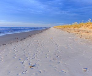 Nannygoat Beach
Nannygoat Beach, the most readily accessible beach on Sapelo, provides an assortment of geological features.
The sand itself has a history. Differing in composition from the Pleistocene sands of the central part of the island, this fine grained, well sorted quartz sand has originated most recently from the landward transport of sand from the shallow continental shelf, primarily transported shorewards by wave energy.
Mud on the beach comes from several sources. Soft, oozing fecal mud is found in the troughs of the runnels. This is derived from the activities of ghost shrimps and tube worms inhabiting the lower beach. Larger mud balls (looking deceptively like small stones) may be found occasionally. These result from the breakup of older Holocene marsh terraces which periodically become exposed on the beaches.
The beach is an area characterized by sand, tides, wind and waves. As it can vary from season to season, day to day, and in a storm or calm weather, so those organisms, which live here, have to grow opportunistically.
The low water mark has its characteristic fauna. This is the area in which to find hermit crabs scurrying about in their borrowed shell and sea pansies lying like purple valentine hearts on the sand surface. In the retreating waves small amphipods – looking and moving like overgrown fleas – are eagerly sought by sandpipers and other shorebirds.
The lower beach provides only indirect clues to many of its other inhabitants. These spend their lives buried below the surface and their burrow entrances or linings are seen much more commonly than are the architects of the burrows. The ghost shrimp (Callianassa) produces a characteristic array of fecal pellets on the sand surface, and when the wave swash has removed the top few centimeters of sand, the thick mud tube entrance to its burrow may be found readily. Onuphis, a tube worm, produces thin parchment-like tubes, composed of chitin covered with fine sand, while another worm Diopatra cements pieces of shell and Spartina debris into its distinctive tube.
Further up the beach, the community is constrained by the shifting nature of the substrate, by the physical effect of currents and wave motion at high water, and by desiccation at low water. Residents tend to burrow into the sand; deposit feeders are found more often in low energy, silty areas while filter feeders appear to prefer sandy high energy areas. This then is an area where the activity appears clandestine. At low tide ghost crabs furtively search the beach debris for an easy meal, and beach hoppers and smaller crabs burrow under stranded horseshoe crabs and Spartina wrack deposited at the high tide line.
In the shallow water in ripple marks and runnels, colored patches may be seen. The colors are brought about by the presence of micro-algae (microscopic one-celled simple plants), euglenoids producing green patches and diatoms producing golden patches. The beach in warmer weather and low light conditions (early morning, late afternoon and overcast weather) shows intense patches of color, especially between low and mid-tide levels. Euglenoids are motile and may be found at greater depths below the sand surface as the intensity of the light increases throughout the day.
One member of the animal kingdom which is often found stranded on the beach among the debris on the high tide line is the plant-like, often brightly colored gorgonian coral. Gorgonians require a solid base on which to grow. A profuse mass of gorgonians can be seen on debris at the bottom of Cabretta Creek at very low tides and it is assumed that this may well be the origin of the majority of the material found on the beach.
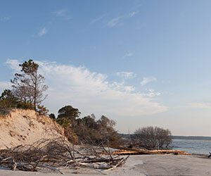 Cabretta
Beyond Nannygoat is another Holocene barrier beach know as Cabretta. At its northern end there is an eroded relict Holocene saltmarsh (X) exposed in a series of terraces, representing at least three subenvironments. Oyster clumps reflect earlier tidal creek banks. The presence of mussels indicates short Spartina high marsh. The sandy sediments and Salicornia and Juncus stems represent a different, even higher marsh. This area also provides mute testimony to the massive erosion of more recent beach sands from this northerly aspect.
Another feature of north Cabretta is the presence of washover fans. These are points where beach sand has been driven landward to overlie the modern marsh and are formed by the erosion of the dunes.
Central Cabretta currently has a slough behind the beach foredunes which has varied greatly in character; it has been both open to high tide influence and cut off by a bar to become self-contained. Such a feature may last weeks or years depending on circumstances. This slough has already developed a limited saltmarsh environment of its own.
The ‘big hole’ (Z) area comprises the northern end of Nannygoat Beach and the southern end of Cabretta, which are separated by Cabretta Creek. This is an area of erosion, as can be seen by the large number of uprooted trees and the exposure of old saltmarsh muds as a result of a significant retreat of the shoreline.
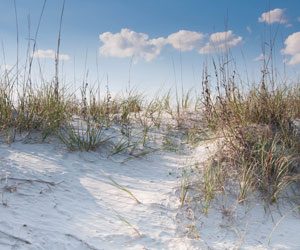 Dunes
Dunes
Fragile by their very nature, dunes are formed when windblown sand accumulates around an obstruction. This may be insubstantial, and dunes when first formed are quite unstable, prone to”blowout” by strong winds or subject to”washover” from storm waves and wind.
The primary sand dune can vary between poorly developed to well developed on Nannygoat Beach. It is an instant barometer of recent events. After storm waves, its eroded face will show layering of a variety of sand types, sometimes accented by wind erosion. Bioturbation or disturbance by biological agents now shows as disruptions of these layers by the growth of plant roots or by animal burrows. By contrast, accretion occurs after a period of calm weather with onshore winds, and the sand may be seen to be building up and partially burying obstructions like live plants and debris stranded beyond the high tide mark.
At the southern end of Nannygoat Beach, the lines of dunes swing around the corner in great arcs. An aerial view of this area is one of the more spectacular sights of the island.
The road to the lighthouse (F) lies on a former barrier spit, curving around an area of saltmarsh approximately _ of a mile wide. The roadside pools seen here are borrow pits, the source of soil used for making the road. This spit is of Holocene age, and it parallels the even more recent Nannygoat shoreline where it swings to the northwest along Doboy Sound.
Accretion (building up) can be seen on Nannygoat. The cabana by the roadside which was on the beach in the 1950’s now lies several hundred feet behind the dune line.
As the dunes themselves are capable of movement, so must their flora and fauna be capable of contending with shifting substrate. They do this by a number of strategies. The plants of the foredunes are particularly well adapted to their situation, having a variety of ways to bind the loose sand; extensive vertical or horizontal root and rhizome systems, heavy seed production or a growth pattern which functions as a wind baffle and traps the blowing sand. They must be salt tolerant and capable of withstanding dessication.
The most spectacular dune plant of Sapelo is undoubtedly the sea oats (Uniola paniculata). Not only are they beautiful, but also highly functional in binding the dune structure together. Sea oats are protected in Georgia, and may be collected only by special permit.
Beach elder (Iva imbricata) and panic grass (Panicum amarum) bind the sand, while water pennywort (Hydrocotyle sp.) and morning glory (Ipomoea sp.) form a mat of creepers binding the surface. Perhaps the least pleasant encounters for the unwary barefoot walker are those with the thorns of sandspur (Cenchrus sp.) and prickly pear.
The animals of the foredunes are characterized by their mobility and opportunism. Ghost crabs forage both in the dunes themselves and on the beach, and rattlesnakes or their tracks are often seen among the dunes. Many of the animals are seasonal. There are a wide variety of insects to be seen in the warmer months and, in the more isolated dunes at Cabretta, oyster catchers and other bird’s nest.
More stable interdune habitats are sometimes categorized according to vegetation type. Interdune meadows may be composed of sea oats, beach elder, panic grass, pennywort and further away from the effect of sea salt, prickly pear, Muhlenbergia with its rosy pink heads, and occasionally a tall spike of the Spanish bayonet (Yucca sp.)
Dunes form parallel to the shoreline, and in their lee, shrub thickets form, protected from the wind and salt spray. This pattern is not always readily discernible from ground level, but it provides one of the more spectacular aerial views.
Plants of the shrub thickets are wax myrtle, redcedar (Juniperus sp.), groundsel (Baccharis sp.) and tamarisk. These provide shelter for many of the small birds visiting the island.
The maritime forests contain live oak (Quercus virginiana), redcedar and pines and are the second line of defense against the incursions of the sea. They are well established on “stable” dunes, inland. However, there are some sites on North Nannygoat and Cabretta where the beach has eroded back to the maritime forest
Upland Areas
 Maritime Forest
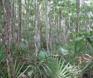
Forests on the island vary between upland maritime, lowland hardwood and old and new pine plantations. As part of their management plan, the Department of Natural Resources is removing diseased and stunted trees from areas of pine forest, planted in the 1950’s. The objective is to provide open ground for deer and turkey, as well as promoting the healthy growth of the remaining trees.
As a habitat, upland maritime forest has a much more varied ecological assemblage than the pine forests. This is a mixed oak-hardwood forest community of live oak, laurel oak, bay, holly, magnolia, cabbage palm and slash pine, with wax myrtles, broomsedge and panic grass at ground level.
Live oaks are always spectacular, but even more with age as their gnarled, tortured trunks support a wide assortment of vines and epiphytes.
An epiphyte is a plant which grows on the surface of another plant, drawing its moisture and nutrient requirements from the air. Live oak is host to two major epiphytes, resurrection fern and spanish moss. Resurrection fern received its name from its capacity to spring to life after a long dry period or a winter of apparent death. Spanish moss is a bromeliad and distantly related to the pineapple. Its tiny green flowers are barely distinguishable, and the distinctive flowing “moss” is, in reality, an interlocking mat of six-inch long plants.
Different vines become apparent at different seasons. Virginia creeper and poison ivy trace their paths up the tree trunks with glowing colors in the fall. Trumpet vine, cherokee rose and wisteria (introduced) are most noticeable in spring, while in summer grapevines weigh down trees and bushes alike under a heavy load of green leaves.
The lowland maritime forest is seen in the wetter lower lying areas of the island. It also is a mixed community, with live oak, water oak, loblolly pine, black gum, sweetgums, and sweetbay, with a shrub cover of wax myrtle and saw palmetto and a generous sprinkling of muscadine grapevines and blackberry bushes. In fall, the sweetgums become particularly showy. They are most noticeable on lower areas of the west perimeter road.
There is a pond, not readily accessible, lying not far from the road which heads east from Chocolate. It is a shallow pond, filled with iris, having a slightly deeper area surrounded by swamp black gums with buttressed roots, in whose branches nest Snowy Egrets. In the very tops of the tall pines surrounding the pond are the nests of the Great Blue Heron. Snakes and frogs are very evident in the water, among the iris plants.
Pines and palmetto are features of the Pleistocene soils of Georgia. Extensive pine forests occur on Sapelo today but much of their presence is a result of deliberate plantings in ditched and drained areas. In natural situations, longleaf pines are found in drier sites than slash pines, and pond pines are associated with more acid and poorly drained soils.
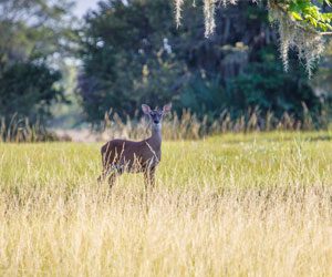
Associated with the more open pine areas are gallberry and blueberry bushes. This is an environment with an abundance of wildlife such as king snakes, diamondback rattlers and rat snakes. It is also an area suitable for management for deer and turkey, and so tree thinning, prescribed burning and mowing, in combination or separately, may be used by the Department of Natural Resources to enhance the standing stocks of deer and turkey.
 Raccoon Bluff
Raccoon Bluff (W) is reached by traveling eastward from the church (V) along a short road. This eroded bluff provides an excellent opportunity to examine Pleistocene sediments (Silver Bluff age 40,000 year B.P. ). Fossil ghost shrimp burrows found 3 1/2 feet above mean sea level indicate that when these sediments were deposited the relative sea level was an ocean beach. Poorly preserved marine shells are found in some sections of the bluff. Further along the creek bank to the northwest, this grades into old and less stable dune structures. The northeastern side of the creek is made of the encroaching modern (Holocene) sediments of Blackbeard Island.
 R.J. Reynolds Wildlife Management Area
The R. J. Reynolds Wildlife Refuge is operated by the Department of Natural Resources Game and Fish Division. It occupies more than 10,000 acres mostly to the north of the fence which crosses the island from the vicinity of the Post Office across to the East Perimeter Road not far from the First African Baptist Church in the Hog Hammock Community. The land was purchased in 1969 from Mrs. Annemarie Reynolds with funds obtained from State (25%) and Federal (75%) sources (U. S. Fish and Wildlife Service, Wildlife Restoration Fund).
Its prime purpose is to manage the populations within its boundaries, with the emphasis on deer and turkey as big game, as well as management of small and non-game species. Deer herds are managed by organized hunts, bow and arrow (adult); and conventional (parent/child). The turkeys are provided with appropriate habitat, and when the numbers are adequate, are transported to the mainland to restock areas where they have been depleted.
To this end, a timber management plan for the island has been instituted, old pine forests are being thinned to allow light to penetrate to the forest floor to enhance wildlife habitat. Modification of a number of areas is occurring, with the aim of improving standing stocks of the managed species. Oak hammock will not be modified, but the lowland hardwoods of the duckpond and Bell Marsh areas will be managed to enhance forest wildlife habitat. The longleaf/slash pine habitat is to undergo prescribed burning on a three year rotation, and the open areas, such as those around King Savannah, will be mowed and/or burnt and planted with such appropriate species as Bahia Grass. The plan calls for an eighty-year rotation of pine growth, with 10-15% of the island open field habitat, 60-65% managed pine timber areas, and 20-30% left in its natural state (oak hammock and lowland hardwood).
The D.N.R. office is housed in Long Tabby (J), which was, for a short time, the residence of the Coffins while they were rebuilding the South End house. Close by this building are the ruins of the old sugar mill built by Thomas Spalding.
The D.N.R. runs the ferries, Annemarie and Sapelo Queen, providing passenger transport to and from the island.